Íomhá:CymruMap.PNG
Níl aon taifeach is mó ar fáil.
CymruMap.PNG (514 × 566 picteilín, méid comhaid: 11 KB, cineál MIME: image/png)
| Seo comhad as An Cómhaoin Viciméid. Tá an tuairisc as an leathanach tuairisc Cómhaoin a leanas thíos.
|

|
File:Map of Mediaeval kingdoms of Wales 700-1000.svg is a vector version of this file. It should be used in place of this PNG file when not inferior.
File:CymruMap.PNG → File:Map of Mediaeval kingdoms of Wales 700-1000.svg
For more information, see Help:SVG. |
 |
Achoimriú
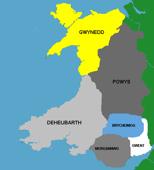
Map o deyrnasoedd Cymru yn y Canol Oesoedd
Map of Mediaeval kingdoms of Wales
Rhion Pritchard
Ceadúnú
| I, the copyright holder of this work, release this work into the public domain. This applies worldwide. In some countries this may not be legally possible; if so: I grant anyone the right to use this work for any purpose, without any conditions, unless such conditions are required by law. |
Stair chomhaid
Cliceáil ar dáta/am chun an comhad a radharc mar a bhí sé ag an am sin.
| Dáta/Am | Mionsamhail | Toisí | Úsáideoir | Nóta tráchta | |
|---|---|---|---|---|---|
| faoi láthair | 14:46, 28 Nollaig 2005 | | 514 × 566 (11 KB) | Rhion | Mao o deynrnasoedd Cymru yn y Canol Oesoedd Map of Mediaeval kingdoms of Wales Rhion Pritchard |
Úsáid comhaid
Tá nasc chuig an gcomhad seo ar 3 an leathanach seo a leanas:
Global file usage
Úsáidtear an comhad seo ar na vicithe seo a leanas:
- Úsáid ar af.wiki.x.io
- Úsáid ar an.wiki.x.io
- Úsáid ar ast.wiki.x.io
- Úsáid ar bn.wiki.x.io
- Úsáid ar br.wiki.x.io
- Úsáid ar ca.wiki.x.io
- Úsáid ar cs.wiki.x.io
- Úsáid ar cy.wiki.x.io
- Úsáid ar dsb.wiki.x.io
- Úsáid ar en.wiki.x.io
- Úsáid ar es.wiki.x.io
- Úsáid ar eu.wiki.x.io
- Úsáid ar fr.wiki.x.io
- Úsáid ar gl.wiki.x.io
- Úsáid ar hu.wiki.x.io
- Úsáid ar is.wiki.x.io
- Úsáid ar it.wiki.x.io
View more global usage of this file.