Íomhá:MapRiversSoutheastCornwallUK.gif

Méid an réamhamhairc seo: 571 × 600 picteilín. Other resolutions: 229 × 240 picteilín | 600 × 630 picteilín.
Taispeáin leagan ardtaifigh den íomhá (600 × 630 picteilín, méid comhaid: 30 KB, cineál MIME: image/gif)
| Seo comhad as An Cómhaoin Viciméid. Tá an tuairisc as an leathanach tuairisc Cómhaoin a leanas thíos.
|
Achoimriú
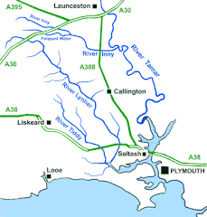
| Tuairisc | A sketch map of the Rivers of southeast Cornwall, United Kingdom |
| Dáta | |
| Foinse | Obair féin |
| Údar | Andy F |
Ceadúnú
Is mise sealbhóir cóipchirt an shaothair seo agus foilsím é faoin gceadúnas seo a leanas:
This file is licensed under the Creative Commons Attribution 3.0 Unported license.
- Is féidir:
- an saothar seo a roinnt – an saothar seo a chóipeáil, a dháil amach, agus a tharchur
- an saothar seo a athmheascadh – an saothar seo a oiriúnú
- Ach amháin má leantar na coinníollacha seo a leanas:
- sannadh – Ní mor creidiúint a thabhairt leis an saothar, faoi mar a shonraigh an údar nó tabharthóir an ceadúnais (ach ná húsáid modh a thugann le fios go thacaíonn sé/sí tú féin nó an úsáid a bhaineann tú as an saothar).
Stair chomhaid
Cliceáil ar dáta/am chun an comhad a radharc mar a bhí sé ag an am sin.
| Dáta/Am | Mionsamhail | Toisí | Úsáideoir | Nóta tráchta | |
|---|---|---|---|---|---|
| faoi láthair | 13:13, 17 Aibreán 2010 | | 600 × 630 (30 KB) | Andy F | {{Information |Description=A sketch map of the Rivers of southeast Cornwall, United Kingdom |Source={{own}} |Date=2010-04-17 |Author=Andy F |Permission= |other_versions= }} Category:Cornwall Category:Rivers of Cornwall [[Category:M |
Úsáid comhaid
Tá nasc chuig an gcomhad seo ar na leathanaigh seo a leanas:
Global file usage
Úsáidtear an comhad seo ar na vicithe seo a leanas:
- Úsáid ar arz.wiki.x.io
- Úsáid ar br.wiki.x.io
- Úsáid ar ca.wiki.x.io
- Úsáid ar en.wiki.x.io
- Úsáid ar eu.wiki.x.io
- Úsáid ar fr.wiki.x.io
- Úsáid ar hu.wiki.x.io
- Úsáid ar it.wiki.x.io
- Úsáid ar simple.wiki.x.io
- Úsáid ar sr.wiki.x.io
- Úsáid ar www.wikidata.org